Koichi Ito
PhD Candidate in Urban Analytics at the National University of Singapore
National University of Singapore
Biography
Koichi Ito is a PhD candidate at the National University of Singapore and has work experience as a consultant at the World Bank Group by leveraging programming skills, interested in researching human mobility and human perception with emerging spatial data sources, such as street-view imagery, and machine/deep learning techniques.
Download my resumé.
- Urban analytics
- Spatial analysis
- Human mobility
-
PhD, 2022-Present
National University of Singapore
-
Master of Urban Planning, 2019-2021
National University of Singapore
-
BA in Liberal Arts, 2015-2019
Soka University of America
Experience
- Researching on the use of street view imagery in urban analytics and GIS studies
- Developing a novel method using street view imagery and computer vision
- Collaborated with memebers of the Senseable City Lab on a project related to digital twin and human perception
- Collaborated with memebers of the CityAI Lab on a project related to transportation and urban analytics
- Collaborated with memebers of the GISense Lab on a project related to urban analytics and GIS studies
- Collaborated with memebers of the Urban Transportation Research Unit on a project related to urban analytics and GIS studies
- Examined the impacts of conflicts on socio-economic indicators in the Central African Republic
- Built Shiny dashboard apps to facilitate analysis of project target indicators in Mozambique, Tanzania, and Romania
- Designed a training on GIS and R for government officials in Tanzania
- Built a data pipeline of PM2.5 data, weather data, and traffic data in Singapore on Azure Synapse with a real-time dashboard on Power BI
- Programed a real-time time-series model with LightGBM in Python on Azure Synapse
- Collected and wrangled a comprehensive data set of more than 4,000 Tokyo-based startups' numerous information, such as addresses, investors, and accelerators in Python (The report is available here.)
- Visualized financial performance of light rail transport system in Toyama prefecture between 2002 and 2019 (The report is available here.)
Recent & Upcoming Talks
Featured Publications
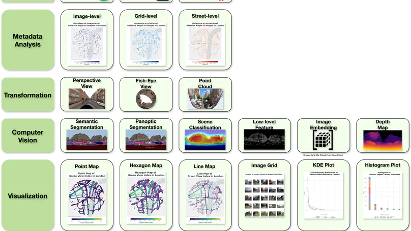
We developed ZenSVI, a free and open-source Python package that integrates and implements the entire process of street view imagery analysis, supporting a wide range of use cases.
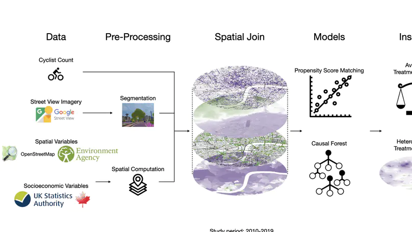
This study used historical street view imagery and cyclist data from London to establish causal relationships between urban features (like vegetation, slope, and bike lanes) and cycling patterns, finding that their impacts vary by population density and providing actionable insights for urban planning.
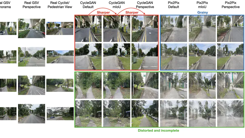
This study introduces a novel AI-based framework to mitigate perspective biases in vehicle-captured street view imagery, successfully translating car-centric views to pedestrian and cyclist perspectives for more accurate bikeability and walkability assessments in urban planning.
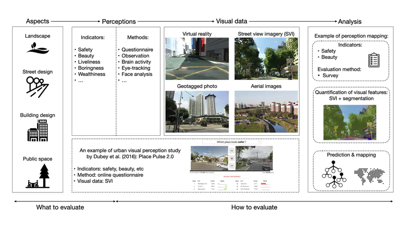
This study reviewed 393 papers on how visual characteristics of the built environment influence urban perception, highlighting trends, limitations, and future research opportunities, and demonstrated the efficacy of using machine learning to semi-automate the review process.
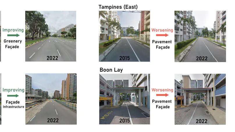
This study introduces a cost-effective, deep learning-based method using time-series street view imagery to evaluate and monitor neighborhood environmental quality, offering a scalable tool for improving urban policy and design.
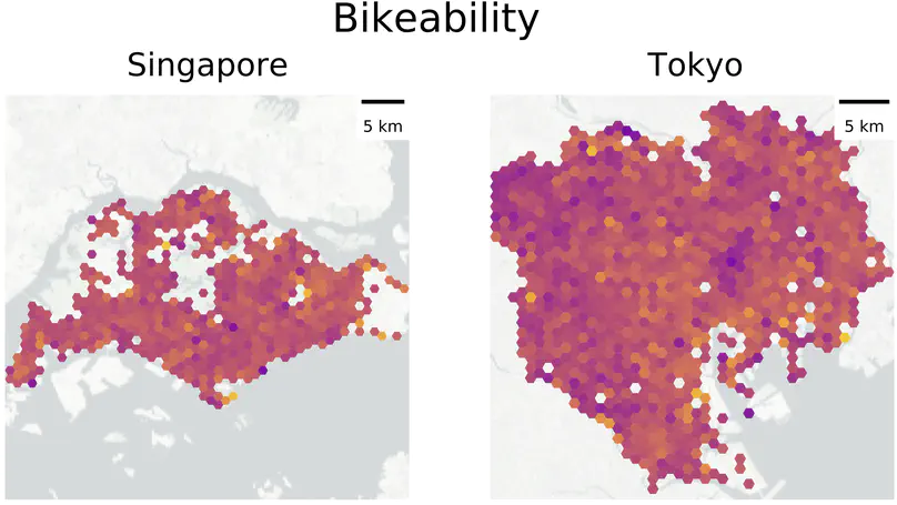
We advanced the comprehensive assessment of bikeability using street view imagery and computer vision.
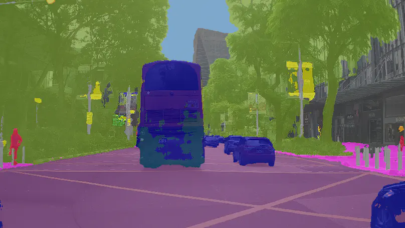
We have provided an extensive review of the use of street-level imagery in urban studies and mapping, through the examination of 250 recently published papers. There are three takeaways we highlight to conclude the paper, which we believe is the most comprehensive one detailing the diverse role of street view imagery in the context of urban analytics and GIS.
Recent Publications
Contact
(I prefer email or twitter DM)
- koichi19960406@gmail.com
- SDE4, College of Design and Engineering, 8 Architecture Dr, Singapore, 117356
- Book an appointment
- DM Me
