Koichi Ito
Koichi Ito
About
Experience
Talks
Publications
Contact
Light
Dark
Automatic
Street View Imagery
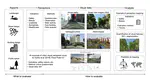
Perceived traffic safety's impact on cycling route choice with street-level images
Cyclists are willing to accept 64 additional seconds of travel time for a one-unit increase in perceived traffic safety.
Koichi Ito
,
Roos Terra
,
Miguel Costa
,
Felix Wilhelm Siebert
,
Francisco Garrido-Valenzuela
,
Carlos Lima Azevedo
,
Filip Biljecki
,
Sander van Cranenburgh
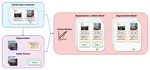
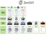
ZenSVI: An open-source software for the integrated acquisition, processing and analysis of street view imagery towards scalable urban science
We developed ZenSVI, a free and open-source Python package that integrates and implements the entire process of street view imagery analysis, supporting a wide range of use cases.
Koichi Ito
,
Yihan Zhu
,
Mahmoud Abdelrahman
,
Xiucheng Liang
,
Zicheng Fan
,
Yujun Hou
,
Tianhong Zhao
,
Rui Ma
,
Kunihiko Fujiwara
,
Jiani Ouyang
,
Matias Quintana
,
Filip Biljecki
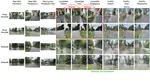
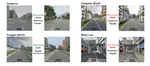
Examining the causal impacts of the built environment on cycling activities using time-series street view imagery
This study used historical street view imagery and cyclist data from London to establish causal relationships between urban features (like vegetation, slope, and bike lanes) and cycling patterns, finding that their impacts vary by population density and providing actionable insights for urban planning.
Koichi Ito
,
Prateek Bansal
,
Filip Biljecki
Translating street view imagery to correct perspectives to enhance bikeability and walkability studies
This study introduces a novel AI-based framework to mitigate perspective biases in vehicle-captured street view imagery, successfully translating car-centric views to pedestrian and cyclist perspectives for more accurate bikeability and walkability assessments in urban planning.
Koichi Ito
,
Matias Quintana
,
Xianjing Han
,
Roger Zimmermann
,
Filip Biljecki
Examining the Causal Impacts of the Built Environment on Cycling Activities Using Time-series Street View Imagery
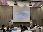
I attended IATBR 2024 in Vienna, Austria this week and presented my work on the causal impacts of visual elements on cyclist activities!
Jul 15, 2024 12:00 AM
University of Vienna, Austria
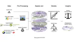
Understanding urban perception with visual data: A systematic review
This study reviewed 393 papers on how visual characteristics of the built environment influence urban perception, highlighting trends, limitations, and future research opportunities, and demonstrated the efficacy of using machine learning to semi-automate the review process.
Koichi Ito
,
Yuhao Kang
,
Ye Zhang
,
Fan Zhang
,
Filip Biljecki
Assessing the Equity and Evolution of Urban Visual Perceptual Quality with Time Series Street View Imagery
This study introduces a cost-effective, deep learning-based method using time-series street view imagery to evaluate and monitor neighborhood environmental quality, offering a scalable tool for improving urban policy and design.
Zeyu Wang
,
Koichi Ito
,
Filip Biljecki
Advancing urban modeling with emerging geospatial datasets and AI technologies
I was invited to talk about my research on street view imagery to a group of audience from government agencies and industries
Oct 5, 2023 12:00 AM
Sheraton Towers, Singapore
Sidewalk the Talk: Translating street view imagery to correct perspectives to enhance bikeability and walkability studies
The study develops a new method using deep learning to correct perspective biases in street view imagery, improving the assessment of active transportation infrastructure from the viewpoint of cyclists and pedestrians.
Oct 5, 2023 12:00 AM
Sands Expo and Convention Centre, Level 3
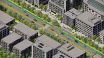
Assessing bikeability with street view imagery and computer vision
Can we improve the scalability of bikeability assessment with street view imagery?
Koichi Ito
»
Cite
×